
Adamawa State postal code is diversified into the six-digit code assigned to the various towns, villages, districts, areas, and places that constitutes the local government areas for the purpose of sorting mail.
Nicknamed the Land of beauty, sunshine, and hospitality, Adamawa is one of the thirty-six (36) states in Nigeria. It is located in the Northeastern geopolitical zone bordered by Gombe to the west, Borno to the northwest, and Taraba to the southwest. Adamawa State was formed in 1991 when the former Gongola State was divided into Adamawa and Taraba states. Aside from being the eighth largest state in Nigeria with about 36,917 km2 (14,254 sq mi), Adamawa State is one of the least populated states in Nigeria. The state is mainly composed of the highlands of mountains and its population is about 4.25 million as of 2016.
How Many Local Governments Are In Adamawa State?
Adamawa State has twenty-one (21) local government areas with four administrative divisions namely Adamawa, Ganye, Mubi, and Numan. The state has about 60 ethnic groups and twenty-eight languages but it is mostly dominated by tribes like the Fulani and the Bachama.
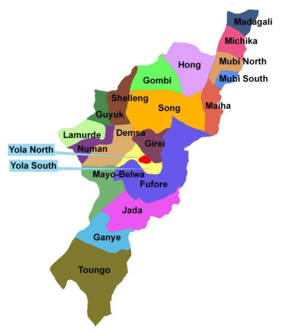
List Of Local Government Areas In Adamawa State
- Demsa
- Fufore
- Ganye
- Girei
- Gombi
- Guyuk
- Hong
- Jada
- Lamurde
- Madagali
- Maiha
- Mayo-Belwa
- Michika
- Mubi North
- Mubi South
- Numan
- Shelleng
- Song
- Toungo
- Yola North (State capital)
- Yola South
How the Nigerian Postal Code System Works
Nigeria as a country does not have a single postal code but its streets, villages, towns, and cities 6 are divided into postal areas with their respective codes.
The Nigerian Postal Service which is responsible for providing postal services in Nigeria divided the country into nine regions, which make up the first digit of the code. The second and third digits combined with the first, are the dispatch district for outgoing sorting. The last three digits represent the delivery location which can be any of the following; a post office facility, a rural area, or an urban area.
The postal head office in every region has its’s code that ends with 0001 and the lowest postcode is 100001 while the highest postcode is 982002. For Instance, Ikeja HQ in Lagos is 100001; The postal code for Nigeria as a country is 23401.
Adamawa State Postal Codes and Zip Codes
A postal code is a series of digits or alphabets and digits assigned to geographical areas designed to receive mail. They are strings of numbers or alphabets that help postal services determine where a mail is sent.
The postal code for Adamawa as a state is 640001. It is, however, important to note that Adamawa State’s postal code is the same as Adamawa State’s zipcode. This is because, in Nigeria, the term postal code is officially recognized and used while in the USA it is officially called zip code.
Based on the Nigeria Postal Service arrangement, all the Local Government Areas in Adamawa State use different postal codes and sometimes the districts and wards within those local governments have varying postal codes too. In accordance with Nigeria Postal Service (NIPOST), here is a complete list of local governments in Adamawa State and their Postal Codes.
Demsa Local Government Area Postal Codes
Demsa LGA is situated in the town of Demsa. The districts under the local government are Gwamba, Nasarawa Demsa, Bille, Dilli, Dong, Dwam, Kpasham, Mbula Kuli, Bali, Borrong, Barinkin Jatau, Bomni, Bujin Kona, Dakkli, Dem, Donwa, Guri, Kpankpai, Kpasham.
Each of these districts uses different postal codes. Here are districts, towns, and villages with their postal codes in Demsa local government;
- Bali – 642109
- Bille – 642110
- Borrong- 642105
- Demsa – 642103
- Dong- 642108
- Gwmba – 642107
- Mbula- 642102
Fufure Local Government Area Postal Codes
Fufore LGA is both a town and the administrative center of the local government area. The area council is made up of the districts of Fufore, Mayo Inne, Gurin, Daware, Malabu, Nyibango, Riba, Verre, Beti, Farang, Ribadu, Yadim, etc.
The postal codes for the towns and villages under Fufure local government include:
- Daware — 640108
- Gurin — 640104
- Beti Giware – 640105
- Malabu — 640103
- Farang – 640107
- Mayo-Inne — 640106
- Nyibango — 640109
- Mayo-Inne — 640106
- Nyibango — 640109
- Ribadu — 640107
- Verre — 640105
Ganye Local Government Area Postal Codes
Ganye LGA is located in the town of Ganye, and the area council consists of the districts of Jaggu, Gurum, Gamu, Sugu, Timdore, Yebbi, Dabosino, Bagana.
The postal codes for the towns and villages under Ganye local government include:
- Banarikiuso — 642115
- Gurum — 642116
- Jaggu — 642114
- Sugu — 641111
- Timdore — 641112
- Yebbi — 64111322
Grei Local Government Area Postal Codes
Girei local government is located in the town of Girei. This local government area consists of the districts of Gereng, Jera Bakari, Jera Bonyo, Modire, Vinikilang, Tambo, Darki, Wuro Dole and Damare.
The towns and villages under Grie use the postal code 652105
Gombi Local Government Area Postal Codes
Gombi Local government area doubles as a local government area center and the area council consists the towns of Gombi, Boga, Duwa, Gabun, Garkida, Gombi North, Gombi South , Guyaku, Tawa, Yang, Lala and Dingai.
The postal codes for the towns and villages under Gombi local government include:
- Ga’Anda — 652101
- Garkida — 652109
- Guyaku — 652108
- Lala — 6521072
Guyuk Local Government Area Postal Codes
Guyuk local government area has its administrative headquarters in Guyuk Town The area consists of districts of Bobini, Bodeno, Banjiram, Chikila, Dukul, Dunma, Lokoro, Kola, Purokayo, Arah, Bodeno, Dakiti, Doma, Dumburi Fulani, Gadajuga, Gargijik, Gimakurje, etc.
The postal codes for the towns and villages under Guyuk local government include:
- Banjiram — 643110
- Bobini — 643111
- Chikila— 643107
- Dukul — 643108
- Dumna — 643110
- Guyuk — 643101
- Kola — 643112
Hong Local Government Area Postal Codes
Hong LGA has its headquarters in the town of Hong and the area council consists of districts of Gaya, Daksiri, Dugwamba, Hong, Kuliyi, Uba, Garaha, Husherezum, Kwarhi, Mayo Lope, Shangui, Thilbang, Bangshikai, Pella, Mbanga, Mugwalar, Shashau, Washim, Zah.
The postal or zip codes for the towns and villages under Guyuk local government include:
- Daktsi— 650111
- Dugwamba— 650109
- Gaya — 650107
- Hong — 650107
- Kuliyi — 650108
- UBA — 650111
Jada Local Government Area Postal Codes
Jada LGA is a town and doubles as a local government area headquarters of Adamawa State, and the area is made up of the districts of Jada, Koma, Danaba, Leko, Mapeo, Mbulo, Mayokalaye, Yelli & Nyibango & villages like Nadeu, Nagum, Dagula, Jamtari, etc.
The postal or zip codes for the towns and villages under Jada local government include:
- Danaba — 641127
- Jada — 641107
- Leko — 641108
- Koma — 641109
- Mayo-Kalaye — 641124
- Mbulo — 641123
- Nyibango — 641122
- Yelli — 641127
Jada Local Government Area Postal Codes
Lamurde is also a town and serves as the local government area headquarters of the council. The area covers the towns of Gyawana, Latiya, Dubwangun, Mgbebongun, Ngbakowo, Opalo, Rigange, Kwah, Suwa, Waduku, Jutingal, Kowei, Kubaje, Labawa, etc
The postal or zip codes for the towns and villages under Jada local government include:
- Gyawana — 642114
- Kwah — 642116
- Lamurde — 642104
- Suwa — 642117
- Waduku — 642115
Madagali Local Government Area Postal Codes
Madagali LGA is the administrative headquarters of the local government area in Adamawa state. The local government which is adjacent to the border with Cameroon was created in 1991, the same year the state was created and it consists of five districts with villages that include Bebel; Chakawa; Ghunilse; Gilma; Sukur Daurawa; Sukur Settlement; Turtakiva; Viengo; Dagali; Gadamayo; Kirching.
The postal or zip codes for the towns and villages under Madagali local government include:
- Duhu — 651111
- Gulak — 651113
- Kirchinga — 651110
- Madagali Town — 651102
- Sukur — 651112
Maiha Local Government Area Postal Codes
Maiha Local government area is located in Maiha Town. The town has an estimated population of 188,942 inhabitants and it is made up of districts and towns that include Belel, Mbila, Pakka, Vokuna, Sarau, Humbutudi, Koonkol, Gari, Manjekin, Mayonguli. Tambajam, Alamisa, Bodeje, Jamtari, Boloko, Bungel, Kasagila, Kirdagirma, Wuro Kurori.
The postal or zip codes for the towns and villages in Maiha local government include:
- Belel — 650106
- Maiha — 650104
- Mbila — 650115
- Pakka-Vokuna — 650214
- Sarau — 650105
Mayo-Belwa Local Government Area Postal Codes
Mayo-Belwa local government area is in the town of Mayo-Belwa. With an estimated population of about 212,534 inhabitants, the local government area consists of the towns and villages of Bajama, Mayo Lamja, Binyeri, Mayo Farang, Tola Jabu, Binkola, Chukkol, Garu, Gengle, Kauram, Ndikong, Ribadu, Sindigawa, Tugga, Wappa, Yoffo, Gijaro, Labara.
The postal or zip codes for the towns and villages Maiha local government include:
- Bajama — 642121
- Binyeri— 641103
- Mayo Belwa town — 641101
- Mayo Farang — 641102
- Mayo Lamja — 642120
Michika Local Government Area Postal Codes
Michika LGA is a big commercial town & doubles as a local government area headquarters. The area is located directly across the border from the famous tourist site of Mcedigyi in vecemwe Rhumsiki in Cameroon. It consists of the districts of Bazza, Futa, Garta, Madzi, Michika, Nkafa, Zah, Minkisi, Ghunchi, Jigalambu. Wuro Ngiki, Moda, Diaka, Ghenjuwa, Sina.
The postal or zip codes for the towns and villages in Michika local government include:
- Bazza — 651103
- Futu — 651106
- Garta — 651105
- Madzi — 657108
- Michika town — 657101
- Nkafa — 651107
- Zah — 651104
Mubi North/South Local Government Area Postal Codes
Mubi North LGA is one of the LGAs in the state with its administrative center in Mubi North made up of Mayo Bani, Muchalla, Mobu, Bahuli, Cha, Digil, Didif, Kelluje, Kwa, Jerengol Kotirde, Besto, Gyumbula, Kamnda, etc.
Mubi South, on the other hand, is sited in Gella town which is part of the Mubi Emirate. The LGA is made up of several towns and villages that include Duvu, Chaba, Girburum, Gella, Gude, Kwaja, Lamorde, Yadafa, Mujara, Nassarawo, Nduku, and Mugulbu.
The postal or zip codes for the towns and villages of Mubi North and Mubi South local government include the following
- Bahuli — 650113
- Mayo Bani — 650102
- Mobu (Ruru) — 650101
- Muchalla — 650112
- Airfield — 650212
- Yelwa Ward — 650272
- Shuware Ward — 650211
- Kochifa Ward — 650272
- Lukuwa — 650221
- Wuro Jibirward — 650251
- School of Arts — 650231
- Wuro Patuji — 650232
- Nasarawa — 650241
- Industrial — 650261
Numan Local Government Area Postal Codes
Also called Nomweh which means ‘Hiltop’, Numan Local Government Area is a port town located at the confluence of river Benue and the Gongola river. The town doubles as a town and LGA headquarters with the area council covering the districts of Bakta, Bare, Bodwai, Kiri, Libbo, Dutse, Numan, Shelleng and Vulpi.
The postal or zip codes for the towns and villages in Numan local government include:
- Bakta — 643104
- Bare — 642112
- Bodwai — 643106
- Kiri — 643105
- Libbo Dutse — 643103
- Numan — 642101
- Shelleng — 643102
- Vulpi — 642111
Shelleng Local Government Area Postal Codes
Shelleng Local Government Area is located in the town of Shelleng. The LGA shares borders with the Guyuk and Girei LGAs and is made up of districts that include Shellenge, Bodwai, Bakta, Gundo, Jumbul, Kiri, Ketembere, Libbo and Tallum,
The postal code for the towns and villages under Shlleng is 643102.
Song Local Government Area Postal Codes
Song Local Government Area is a town in the state. The local government has an approximate population of 25,000 with the area council consisting of districts of Song, Dumme, Dirma, Kilange, Funa, Gudu, Mboi, Kilange, Hirna, Gari, Waje, Suktu, Zumo, Waltandi and Ditera.
The postal or zip codes for the towns and villages in Song local government include:
- Ditera — 652104
- Mboi — 652107
- Song — 652102
- Waltadi — 652102
- Zumo — 652103
Toungo Local Government Area Postal Codes
Toungo LGA is a town and local government area in Adamawa State and the area comprises several towns and villages which include Taungo, Dawo, Kogin Baba, Kiri, Gumti, Bavehi, Kubali, Labore, Sabongai, Kilta, Galabje, Nuibago, Timdoga, Tapare, Tafida, Adamu, Biniji, Ganti, etc.
The postal or zip codes for the towns and villages Toungo local government include:
- Dawo — 641119
- Gamu — 641118
- Kini — 641117
Yola North/South Local Government Area Postal Codes
The city of Yola is generally regarded as the seat of the traditional Adamawa emirate. Yola North Local Government Area consists of districts of Yola North, Ajiya, Doubeli, Alkalawa, Gwadabawa, Karena, Limawa, Luggere, Yelwa, Sebore, Bole, Changala, Wuro Yanka, Goduwu, and Gongoshi.
Yola South LGA is sited in the city of Yola consisting districts of Bako, Adarawo, Bole Yolde Pate, Makama i & ii , Namtari, Ngurore, Yolde Kohi, Mbamoi, Namtara, Bbamba, Maalkobhi, Rugange, Sebore, Njoomboliyo, Njombvoli Fulan, Njomboli Fulani, etc.
The postal or zip codes for the towns and villages in Yola North and South local government include:
- Lamido Palace — 640230
- Federal Housing — 640231
- Namtara — 640102
- Yola (Rural) — 640101
Jimeta Town Postal Codes
Jimeta is a popular town in Adamawa State that lies along the Benue River in the state’s capital city Yola. The town is the administrative headquarters of the defunct Gongola. It is also one of the towns that are closer to Nigeria’s capital Abuja. The town is also linked by road to Bombi, Mubi, Bama, and Maiduguri; a ferry service in the town crosses the Benue River. Villages and towns under Jimeta include Majalisa, Jambutu, Gwadabawa, Karewa, Luggere, and old G.R.A.
The postal or zip codes for the villages under Jimeta town are as follows:
- Old G.R.A — 640221
- Dubeli — 640284
- Karewa— 640261
- Luggere— 640281
- Demsawo— 640282
- Majalisa— 640211
- Jambutu— 640283
- Gwadabawa— 640212